 Lýsigagnagátt
Umbrotasvæðið á Sundhnúksgígaröð 2023 - 2025 -- Sundhnúksgígar Eruptions 2023 - 2025
IS:
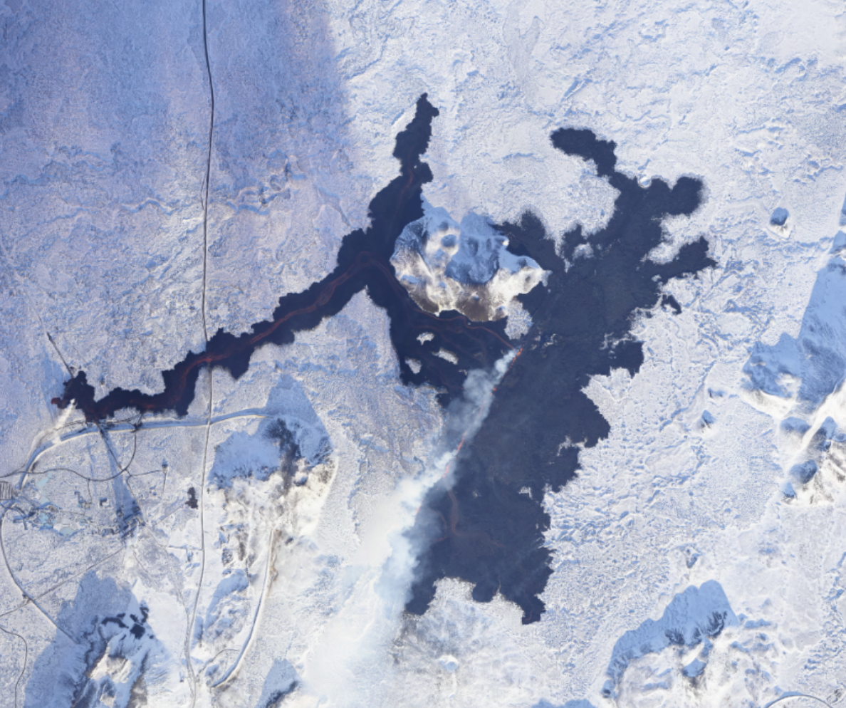
Myndkort af atburðum sem hafa átt sér stað á Reykjanesi frá nóvember 2023 - april 2025 hafa orðið til í samstarfi Náttúrufræðistofnunar, Veðurstofu Íslands og Almannavarnir, sem hluti af viðbragðsáætlunum, hættumati og rannsóknum.
Í öllum atburðum voru teknar loftmyndir og hæðarlíkön, útlínur hrauns útbúin ásamt myndkortum. Myndkortin eru aðgengileg í gegnum WMS þjónustu og á Umbrotasjá ( https://kortasja.lmi.is/mapview/?application=umbrotasja).
EN:
Orthomosaics of the events occurring on the Reykjanes peninsula, SW Iceland, in November 2023- April 2025 have been created in a collaborative effort between the Natural Science Institute of Iceland (Náttúrufræðistofnun), the Icelandic Meterological Office (Veðurstofa Íslands), and the Civil Protection (Almannavarnir) as part of the response plans, hazard assessments and research.
Upon each event, aerial photographs were collected and Digital Elevation Models (DEMs), lava outlines, and orthomosaics were produced of these events. The orthomosaics are available via WMS and in the Volcano Viewer webpage ( https://kortasja.lmi.is/mapview/?application=umbrotasja). The data was created and distributed typically less than one day after data collection.
Simple
- Date (Creation)
- 2023-02-11
- Status
- On going
- Point of contact
-
Organisation name Individual name Electronic mail address Role Náttúrufræðistofnun
Svið Landmælinga og Landupplýsinga
Distributor
- Maintenance and update frequency
- Not planned
- Place
-
-
Loftmyndir
-
Areal imagery
-
Reykjanes
-
Reykjanes peninsula
-
Sundhnúksgígar
-
Sundhnuksgigar
-
eldgos
-
eruption
-
Myndkort
-
Orthomosaic
-
Hæðarlíkan
-
Digital Elavation Model
-
DEM
-
útlínur
-
hraun
-
lava outlines
-
Opin gögn
-
Open Data
-
-
Lykilorð
-
-
Iceland
-
Reykjanes
-
- Access constraints
- Other restrictions
- Other constraints
- no limitations to public access
- Use constraints
- Copyright
- Other constraints
- Attribution 4.0 International (CC BY 4.0)
- Use limitation
-
[IS]
Getið heimilda:
Nafn fyrirtækis, ár. Drónamyndir Umbrotasvæðið á Reykjanesi. Dagsetning myndar. URL (venjulega kort.gis.is eða umbrotasja.gis.is). [Myndefni].
[EN]
Citation:
Company name, year. Drónamyndir Umbrotasvæðið á Reykjanesi [Drone Imagery of Reykjanes Eruptions]. Image date. URL (generally kort.gis.is or umbrotasja.gis.is). [Imagery].
- Denominator
- 1
- Language
- English
- Character set
- UTF8
- Topic category
-
- Imagery base maps earth cover
))
- Reference system identifier
- EPSG:3057 (ISN93)
- Reference system identifier
- EPSG:8088 (ISN2016)
- Distribution format
-
Name Version Tiff
0
WMS
0
Geopackage
Digital transfer options
- OnLine resource
-
Protocol Linkage Name WWW:LINK-1.0-http--link
https://umbrotasja.gis.is/mapview/?application=umbrotasja Umbrotasjá
WWW:LINK-1.0-http--link
https://kort.gis.is/mapview/?app=kort Kortagluggi
WWW:LINK-1.0-http--link
https://www.natt.is/is/midlun/opin-gogn Skilmálar um opin gögn
OGC:WMS
https://gis.natt.is/mapcache/reykjaneseldar/isn93/wms WWW:LINK-1.0-http--link
https://www.natt.is/is Náttúrufræðistofnun heimasíða
- Hierarchy level
- Dataset
- Statement
-
[IS]
Myndirnar voru teknar með PhaseOne iXM-100 MP myndavél. Þessi myndavél er í eigu Náttúrurfræðistofnunar og var fengin með innviðastyrk Rannís til kortlagningar á náttúruvá. Myndirnar voru unnar með Agisoft Metashape (v2) photogrammetric hugbúnaði, í þeim tilgangi að útbúa hæðarlíkön og myndkort.
Gögnin eru uppfærð eftir þörfum.
[EN]
The images were collected with a PhaseOne iXM-100 MP camera. The camera belongs to Náttururfræðistofnun and was acquired through a Rannís Infrastructure grant for mapping of natural hazards. The images were processed with Agisoft Metashape (v2) photogrammetric software, in order to create Digital Elevation Models (DEMs) and orthomosaics.
The data is updated as needed.
Metadata
- File identifier
- 1134f922-4695-4b7e-a33b-a07026aa2282 XML
- Metadata language
- ice
- Character set
- UTF8
- Date stamp
- 2026-02-10T16:40:29
- Metadata standard name
-
ISO 19115:2003/19139
- Metadata standard version
-
1.0
- Metadata author
-
Organisation name Individual name Electronic mail address Role Náttúrufræðistofnun
Distributor
)))