 Lýsigagnagátt
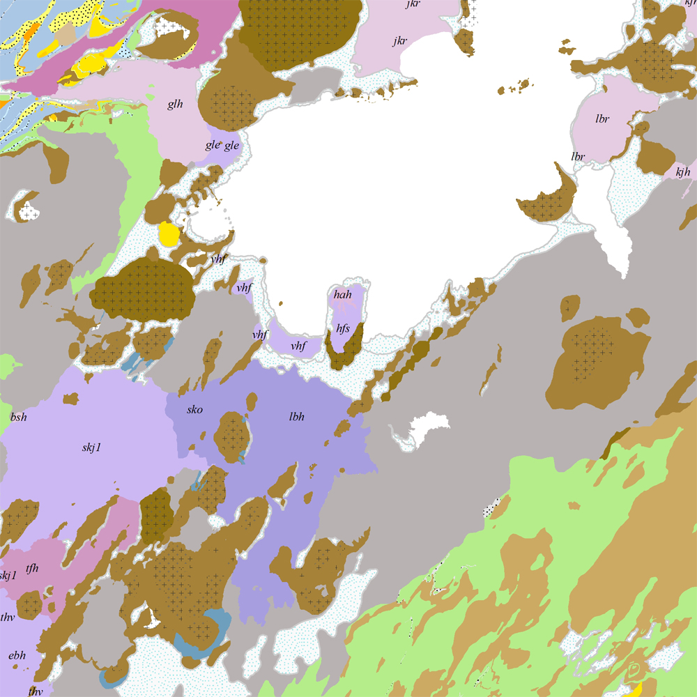
ni_j100v Berggrunnur á Vesturgosbelti – 1:100.000
Þekja [layer] j100v_vesturgosbelti_berggrunnur_1utg_fl:
Gögn fyrir berggrunn ásamt nútímahraunum. [Data showing the bedrock geology, including Holocene lavas.]
Berggrunnur er flokkaður eftir aldri, gerð og samsetningu. Gögn eru flokkuð eftir ÍST120:2012 staðlinum, nema fitjueigindir:
myndunKodi = stuttur kóði sem táknar gerð bergmyndunar,
myndunIS = stutt íslenskt heiti fyrir bergmyndun,
myndunEN = stutt enskt nafn á bergmyndun,
eldstodNafn = nafn eldstöðvakerfis,
kenni = stuttur kóði fyrir hlýskeiðishraun og nútímahraun,
aldur = aldursbil,
Nýr kóði fyrir fitjueigindina 'Tegund storkubergs' (tegStorkubergs): dbas = dílabasalt.
[Bedrock is classified by age, type, and composition. The data follows the ÍST120:2012 data standard with these additional feature attributes:
myndunKodi = short code denoting the rock formation type,
myndunIS = short Icelandic name for rock formation,
myndunEN = short English name for rock formation,
eldstodNafn = name of the volcanic system,
kenni = short codename for interglacial and postglacial lavas,
aldur = age range.
New code for feature attribute 'Tegund storkubergs' (tegStorkubergs): dbas = porphyrytic basalt.]
Simple
- Date (Publication)
- 2021-12-01
- Edition
-
1. útgáfa
- Status
- On going
- Point of contact
-
Organisation name Individual name Electronic mail address Role Náttúrufræðistofnun – Natural Science Institute of Iceland
Point of contact
- Maintenance and update frequency
- As needed
- Theme
-
- Place
-
-
National
-
-
GEMET - INSPIRE themes, version 1.0
-
-
Geology
-
- Access constraints
- Copyright
- Other constraints
-
https://www.natt.is/is/midlun/opin-gogn
Gögnin eru öllum opin – no limitations on public access
- Spatial representation type
- Vector
- Denominator
- 100000
- Language
- English
- Character set
- UTF8
- Topic category
-
- Geoscientific information
- Begin date
- 2019-05-01
- End date
- 2021-06-01
))
- Reference system identifier
- EPSG / 3057 / 7.6.1(9.0.0)
- Distribution format
-
Name Version ESRI ArcGIS File Geodatabase
1.010.8.1.14362
ESRI Shapefile
1.010.8.1.14362
Digital transfer options
- OnLine resource
-
Protocol Linkage Name WWW:LINK-1.0-http--link
https://www.natt.is/is/midlun/opin-gogn/nidurhal-gagna Niðurhal gagna
WWW:LINK-1.0-http--link
https://www.natt.is/is/midlun/opin-gogn Skilmálar (PDF) – Licence (PDF)
WWW:LINK-1.0-http--link
https://jardfraedikort.ni.is/ NÁTT kortasjá 'Jarðfræði Íslands'
WWW:LINK-1.0-http--link
https://www.natt.is Vefur Náttúrufræðistofnunar
WWW:LINK-1.0-http--link
https://www.natt.is/is/midlun/grunngerd-landupplysinga/gagnalysingar-og-fitjuskrar Íslenskt fitjuskrá '600 Jarðmyndun og landmótun' sem tengjast staðlinum ÍST 120 (PDF)
OGC:WMS
https://gis.natt.is/geoserver/wfs?request=GetCapabilities ni:ni_j100v_vesturgosbelti_berggrunnur_1utg_fl
- Hierarchy level
- Feature
- Statement
-
Gögn úr vettvangsvinnu jarðfræðinga NÍ og ÍSOR, ásamt kortlagningu og gögnum S. P. Jakobssonar (2019) af Vesturgosbeltinu unnin á NÍ. Birt jarðfræðikort og greinar frá Kjartansson (1965), Sæmundsson and Noll (1974), Johannesson (1994) og Sinton et al. (2005). Þekja nútímahrauna unnin á NÍ í tengslum við sérstaka vernd náttúrfyrirbæra (2017), en endurskoðuð og bætt í samræmi við vettvangsvinnu og jarðfræðikortlagningu Vesturgosbeltisins. Eldri gögn kortsins hafa verið yfirfarin og endurskoðuð.
[Data is compiled from field observations by geologists at NÍ and ÍSOR, as well as previously published and unpublished datasets including Kjartansson (1965), Sæmundsson and Noll (1974), Johannesson (1994), Jakobsson (2019), and Sinton et al. (2005). Postglacial lava data was compiled at NÍ (NÍ-Kortasjá ‚Sérstök vernd náttúrufyrirbæra‘), revised according to recent fieldwork. The map has been checked and reviewed internally.]
Heimildir [Sources]:
- Jóhannesson, H. 1994. Geological map of Iceland, sheet 2, West-Iceland, second edition. Icelandic Museum of Natural History and Iceland Geodetic Survey, Reykjavik.
- Kjartansson, G. 1965. Geological map of Iceland, sheet 5, Central Iceland. Icelandic Museum of Natural History and Iceland Geodetic Survey, Reykjavik.
- Náttúrufræðistofnun Íslands 2017. NÍ-Kortasjá ‚Sérstök vernd náttúrufyrirbæra‘. Eldhraun á nútíma. 1. útg. mars 2017
- Sinton, J., Grönvold, K. and Sæmundsson, K. 2005. Postglacial eruptive history of the western volcanic zone, Iceland. Geochemistry, Geophysics, Geosystems, 6(12).
- Sæmundsson K. and H. Noll 1974. K/Ar ages of rocks from Húsafell, western Iceland,and the development of the Húsafell central volcano. Jökull 24,40–58.,
- Sveinn P. Jakobsson 2019. Geological map of the western volcanic zone, Iceland.
Metadata
- File identifier
- 78ce2e5b-8400-4ca8-97aa-1a6e8483ecd4 XML
- Metadata language
- English
- Character set
- UTF8
- Parent identifier
-
Jarðfræðikort af Vesturgosbelti 1. útgáfa – 1:100.000
eeca904b-c6b9-42b2-827a-184d1b8ff46e
- Date stamp
- 2025-08-08T11:55:31
- Metadata standard name
-
ISO 19115:2003/19139
- Metadata standard version
-
1.0
- Metadata author
-
Organisation name Individual name Electronic mail address Role Náttúrufræðistofnun – Natural Science Institute of Iceland
Point of contact
)))