 Lýsigagnagátt
Jöklasprungukort 2025 - Glacier Crevasse Map 2025
[IS]
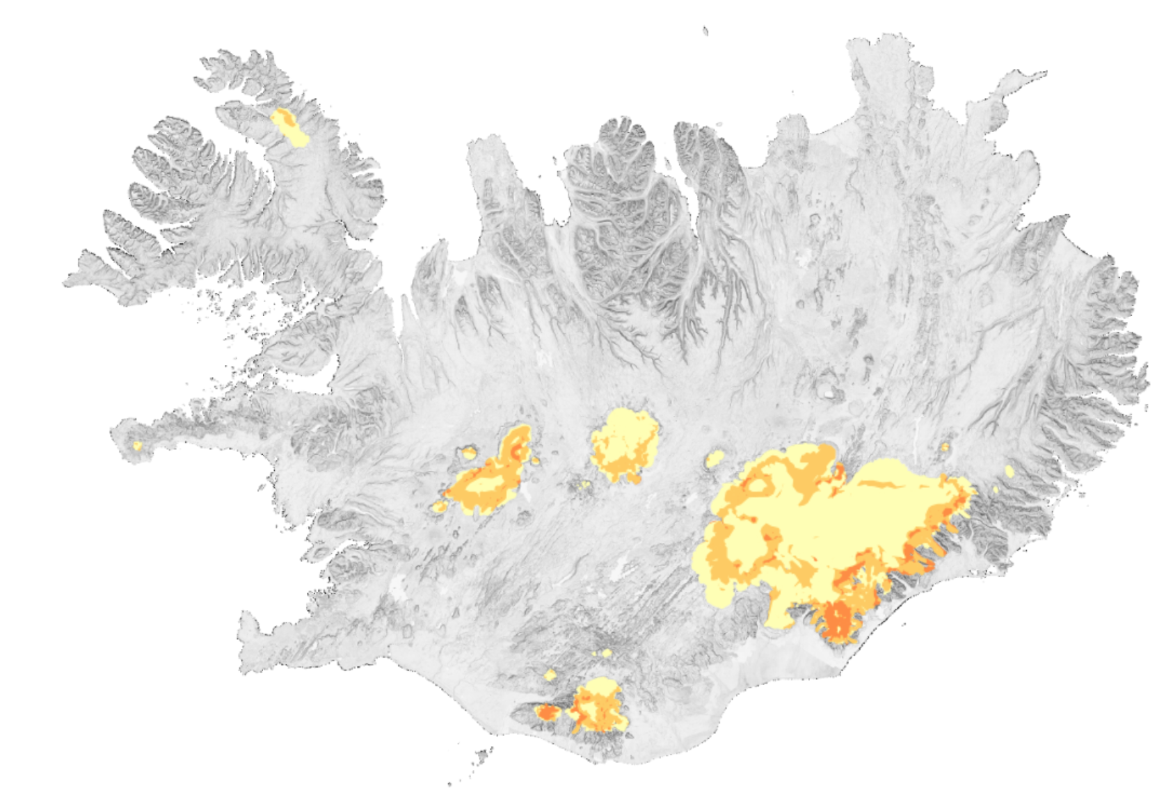
Veðurstofa Íslands geymir gögn um sprungusvæði fyrir 24 íslenska jökla. Kortlagning sprungusvæða er að mestu leyti byggð á gervihnattamyndum og loftmyndum teknum síðsumars og fram á haust þegar snjóþekja er minni. Hæðarlíkön, sigkatlar í yfirborði jökla og þekktar ferðaleiðir og leiðarferlar eru einnig hafðir til hliðsjónar. Notaðar eru útlínur jökla haustið 2025 og jökulsker eru einnig sýnd. Um er að ræða vektorgögn og kortin sýna 3 flokka af sprungusvæðum: 1. lítið sprunginn jökull, 2. mjög sprunginn jökull, 3. breiðar sprungur og mjög hættuleg svæði, og staðsetningu þeirra. Gögnin eru uppfærð á nokkurra ára festi, núverandi útgáfa er frá árinu 2025.
Tekið er á móti upplýsingum um nýjar sprungur á netfanginu jokulsprungur@vedur.is Sprungukortin eru ætluð aðeins til hliðsjónar fyrir jöklaferðalanga en ábyrgð liggur ætíð í höndum þeirra sem ferðast á jökli, en aðstæður geta breyst fyrirvaralaust.
Gögn: Loftmyndir frá Náttúrufræðistofnun og Loftmyndum ehf., SPOT 5 gervitunglamyndir (2002−2008), LIDAR hæðarlíkön (2008−2012), Pléiades gervitunglamyndir (2021−2025), Sentinel-2A gervitunglamyndir (2025), og skámyndir úr flugi frá sumri og hausti 2010−2012.
Nánari upplýsingar: https://safetravel.is/outdoors/crevasse-maps/
[EN]
The Icelandic Meteorological Office hosts a data set on glacier crevasse areas of 24 Icelandic glaciers. The crevasse area mapping is based on satellite and aerial imagery of late summer and fall when the glaciers have least amount of snow cover. DEMs, glacier cauldrons and known travel tracks are also used as reference. The glacier outlines of 2025 are used, and nunataks are also shown. The vector file shows glacier areas that fall into three different categories of crevassed areas: 1. areas with small crevasses, 2. very crevassed areas, 3. wide crevasses and very dangerous areas. The data set is updated every other year approximately and the current version is from the year 2025.
Information about new crevasses can be forwarded to the following email: jokulsprungur@vedur.is. The crevasse maps are intended as guidelines for glacier travels, conditions can change fast, travel at own risk.
Data: Aerial images from the Natural Science Institute of Iceland, Loftmyndir ehf, SPOT 5 satellite images (2002−2008), LIDAR DEMs (2008−2012), Pléiades satellite images (2021−2025), Sentinel-2A satellite images(2025), and oblique photographs from aerial surveys in the summers and fall of 2010−2012.
Further information: https://safetravel.is/outdoors/crevasse-maps/
Simple
- Date (Publication)
- 2026-03-21
- Purpose
-
Location of crevassed areas on Icelandic glaciers
- Status
- On going
- Point of contact
-
Organisation name Individual name Electronic mail address Role Veðurstofa Íslands
Hrafnhildur Hannesdóttir, Ragnar Heiðar Þrastarson
Author Náttúrufræðistofnun
Distributor
- Maintenance and update frequency
- Every other year
- Metadata author
-
Organisation name Individual name Electronic mail address Role Veðurstofa Íslands
Custodian
- Keywords
-
-
jökull
-
glacier
-
sprungur
-
crevasse
-
vector
-
kort
-
2025
-
opin gögn
-
open data
-
öryggi
-
safety
-
- Keywords
-
-
Map
-
- Other constraints
-
Fyrirvari:
Upplýsingarnar í þessu gagnasafni eru eingöngu ætlaðar til upplýsinga og ættu ekki að túlka sem fagleg ráð eða leiðbeiningar. Ferðalög á jöklum hafa í för með sér áhættu og einstaklingum er bent á að gæta varúðar og leita aðstoðar hæfra leiðsögumanna þegar haldið er á jökla.
Hvorki Náttúrufræðistofnun né Veðurstofa Íslands bera ábyrgð á ónákvæmni eða frávikum í gögnunum. Jöklar geta breyst hratt og sprungur eru breytilega, ásamt því að nýjar myndast án fyrirvara og vegna árstíðabundinna breytinga, veðurskilyrða og formgerðar eða tegunda jökla.
Notendum þessa gagnasafns er minnt á að sprungukortlagning þjónar sem vísbending um hugsanlega hættu og er ekki tæmandi mynd af staðsetningu eða aðstæðum sprungna. Það er á ábyrgð einstaklinga að meta staðbundnar aðstæður, gæta varúðar og taka upplýstar ákvarðanir þegar þeir ferðast á jöklum.
Með því að fá aðgang og nýta þetta gagnasafn viðurkenna notendur og samþykkja þá eðlislægu áhættu sem fylgir ferðum um jökla og samþykkja jafnframt að Náttúrufræðistofnun og Veðurstofa Íslands beri enga ábyrgð á afleiðingum notkunar upplýsinganna.
Disclaimer:
The information provided in this dataset is intended for informational purposes only and should not be construed as professional advice or guidance. Traveling on glaciers carries inherent risks, and individuals are advised to exercise caution and seek the assistance of qualified guides when engaging in glacier-related activities.
Neither the Natural Science Institute of Iceland nor the Icelandic Meteorological Office can be held liable for any inaccuracies or discrepancies in the data presented. Glacial environments are dynamic and subject to change due to seasonal variations, weather conditions, and glacier morphology.
Users of this dataset are reminded that crevasse mapping data serve as indicators of potential hazards and are not exhaustive representations of crevasse locations or conditions. It is the responsibility of individuals to assess local conditions, exercise prudence, and make informed decisions when navigating glacier terrain.
By accessing and utilizing this dataset, users acknowledge and accept the inherent risks associated with glacier travel and agree to indemnify and hold harmless the Natural Science Institute of Iceland and the Icelandic Meteorological Office from any claims, damages, or liabilities arising from the use of the information provided.
- Access constraints
- License
- Other constraints
- Spatial representation type
- Vector
- Language
- ice
- Character set
- UTF8
- Topic category
-
- Imagery base maps earth cover
- Inland waters
- Climatology, meteorology, atmosphere
- Begin date
- 2021-01-01
- End date
- 2025-12-01
))
- Supplemental Information
-
ATTACH INSTRUCTIONS AND WORD DOCUMENT HERE?
- Reference system identifier
- EPSG:3057
- Distribution format
-
Name Version
Digital transfer options
- OnLine resource
-
Protocol Linkage Name WWW:LINK-1.0-http--link
https://kort.gis.is/mapview/?app=kort&l=is&c=-2143331,9599130&z=1.7&ls=13790,14135,17855&op=14135_1,17855_1&eg=14333,14119,16166 Kortagluggi Náttúrufræðistofnunnar
WWW:LINK-1.0-http--related
https://safetravel.is/outdoors/crevasse-maps/ Safe Travel Crevasse Maps
WWW:LINK-1.0-http--link
https://vedur.is/ Heimasíða Veðurstofu Íslands
OGC:WFS
https://gis.is/geoserver/vedur/ows?service=WFS vedur:crevasse_map_2025
OGC:WMS
https://gis.is/geoserver/vedur/wms crevasse_map_2025
WWW:LINK-1.0-http--link
https://gis.is/geoserver/vedur/ows?service=WFS &version=1.0.0 &request=GetFeature &typeName=crevasse_map_2025 &outputFormat=SHAPE-ZIP Niðurhal .shp skrár
WWW:LINK-1.0-http--link
https://gis.is/geoserver/vedur/ows?service=WFS &version=1.0.0 &request=GetFeature &typeName=crevasse_map_2025 &outputFormat=application%2Fvnd.google-earth.kml%2Bxml Niðurhal .kml skrár
- Hierarchy level
- Dataset
- Statement
-
v1 2017, Snævarr Guðmundsson; v2 2021, Ágúst Þór Gunnlaugsson
Metadata
- File identifier
- 7a15cac3-7b6d-4d0a-aad3-a1bfe80df381 XML
- Metadata language
- ice
- Character set
- UTF8
- Date stamp
- 2026-04-15T11:55:53
- Metadata standard name
-
ISO 19115:2003/19139
- Metadata standard version
-
1.0
- Metadata author
-
Organisation name Individual name Electronic mail address Role Veðurstofa Íslands
Point of contact
)))