 Lýsigagnagátt
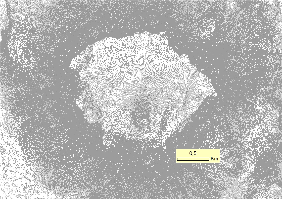
ArcticDEM Herðubreið 2 m hæðarlínur
Á síðustu árum hefur gögnum verið aflað fyrir nýtt landhæðarlíkan norðurhveli jarðar, norðan við 60°N, þar með talið af Íslandi. Almennt er það nefnt Arctic-landhæðaríkan (e. ArcticDEM) og er unnið af Bandaríkjamönnum. Vinnan fer fram við Polar Geospatial Center (PGC) sem er innan veggja Minnesota háskóla. Líkanið er unnið úr gervitunglamyndum og eru notuð myndpör (stereoscopic) frá gervitunglum á borð við WorldView-1, WorldView-2, WorldView-3 og GeoEye-1. Greinihæfni mynda frá þessum tunglum er á bilinu 31-46 cm. Með þessum gögnum er unnið landhæðaríkan þar sem minnstu reitir eru 2x2 m. Þetta þýðir að ef öllu Íslandi er deilt upp í 4 m2 reiti hefur hver slíkur eitt hæðargildi. Þær myndir sem notaðar eru til verkefnisins eru yfirleitt 2-3 ára en allt að 6-7 ára gamlar. Mjög öflugur hugbúnaður er notaður við verkið og hefur miklum gögnum þegar verið komið á framfæri en allir geta sótt gögnin á niðurhalssíðu PGC. Þótt gögnin teljist almennt góð er engu að síður þörf á að lagfæra eða leiðrétta agnúa sem í þeim finnast. Náttúrufræðistofnun hafa sótt gögnin og þar fer fram vinna við lagfæringar þeirra. Þetta sýnishorn fyrir Herðubreið og er dæmi um þá vinnu sem Landmælingar nú hafa með höndum. Gögnin innihalda landhæðarlíkan (2-m-greinihæfni), 2-m-hæðarlínur og hæðarskyggingu (hillshade).
Recently, elevation data has been acquired for a new elevation model for the Arctic, i.e. north of 60°N that includes Iceland. This model is referred to as the ArcticDEM and the project is carried out by the US. The work is conducted by the Polar Geospatial Center (PGC) at the University of Minnesota. The DEM is based on satellite imagery of stereo-pairs from satellites such as WorldView-1, WorldView-2, WorldView-3 and GeoEye-1 that have a resolution of 31-46 cm. The DEM product has a resolution of up to 2 m, which means that if the whole of Iceland was divided into 4 square meter areas, each such area would have an elevation value. The used imagery used is mostly between 2 and 3 years old, up 6 to 7 years old. Powerful software/hardware is used for this project and already immense amount of DEM data has been made available and can be downloaded from the Polar Geospatial Center. Although the data is generally of high quality there is, however, need to carry out considerable work to eliminate clear defects. The National Land Survey has acquired the data and presently work is conducted on gap filling, elevation cone removal and geoid corrections and the Herðubreið DEM is an example this work. The Herðubreið data set consists of a digital elevation model with 2 m resolution, 2 m contour line data set and a hillshade made from the model.
Simple
- Date (Publication)
- 2018-03-21
- Purpose
-
Koma á framfæri hæðargögnum með þéttum hæðarlínum til almennra nota.
To make detailed elevation contour line data available for public use.
- Status
- Completed
- Point of contact
-
Organisation name Individual name Electronic mail address Role Náttúrufræðistofnun
Custodian
- Maintenance and update frequency
- As needed
- Theme
-
-
2-m-hæðarlínur
-
- Theme
-
-
Lykilorð
-
- Access constraints
- Copyright
- Use constraints
- otherRestictions
- Other constraints
- Spatial representation type
- Vector
- Denominator
- 5000
Spatial resolution
Spatial resolution
- Language
- ice
- Character set
- UTF8
- Topic category
-
- Elevation
))
- Reference system identifier
- EPSG / ISN93 / Lambert 1993 (EPSG:3057) / 8.6
- Distribution format
-
Name Version ESRI Shapefile
1.0
Digital transfer options
- OnLine resource
-
Protocol Linkage Name WWW:LINK-1.0-http--link
https://atlas.lmi.is/LmiData/index.php Niðurhalssíða Náttúrufræðistofnunar
- Hierarchy level
- Dataset
- Statement
-
Tveggja metra hæðarlínur fyrir Herðubreið og umhverfi. Gögnin voru unnin í ArcGIS. Upprunalegt hæðarlíkan var þynnt með "focal statistics" (2x2) og einfölduð til að gera hæðarlínur áferðafallegri. Gögnin voru yfirfarin með topology/grannfræði til útilokunar á villum. Gögnin eru unnin úr demi sem hefur 2 fermetra pixilstærð.
Metadata
- File identifier
- aa282983-4fad-4441-982a-484bf051eb6c XML
- Metadata language
- ice
- Character set
- UTF8
- Date stamp
- 2019-09-24T13:27:29
- Metadata standard name
-
ISO 19115:2003/19139
- Metadata standard version
-
1.0
- Metadata author
-
Organisation name Individual name Electronic mail address Role Náttúrufræðistofnun
Point of contact
)))